Few days respite for roads and rivers before next downpour hits region - Met Office
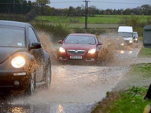
The region's rivers will have a few days respite to drop a bit before the next drenching comes across the UK.
After a few days to dry up the Met Office is forecasting wet and windy conditions will take over by midweek.
And they warn there is the "possibility of disruptive rainfall."
In a forecast issued on Sunday morning the meteorologists say that wet and increasingly windy weather will initially move into the southwest of England and Wales on Tuesday, eventually spreading more widely across the UK through Wednesday.
Scotland is set for persistent heavy rainfall through much of Thursday and Friday as a block of high pressure over Scandinavia causes weather fronts to stall over the county. A Yellow National Severe Weather Warning for rain has been issued there.
The Met Office says there is the potential for significant disruption.
Steven Keates, the Deputy Chief Meteorologist, said: “Many parts of the UK will see a very unsettled spell of weather through the second half of the coming week, into next weekend.
"A number of areas have the potential to see a lot of rain as well as strong winds at times.
"Of particular concern at the moment is eastern and central Scotland where some exceptional rainfall totals could build up, falling on ground already saturated after recent heavy rainfall.
"This could lead to some significant and widespread disruption."
Looking further ahead they say that it looks like low pressure will remain in charge of the UK's weather with potential for further spells of wet and windy weather.
Looking back on the last few days, Dave Throup, who describes himself as a happily retired Environment Agency Area Manager, said Thursday was a very wet day.
He tweeted that many places had seen 20mm or more of rain in the last 24 hours, with 30mm widely, and 50+ on higher ground in Wales.
He added: "Unusual to see such widespread significant totals."
Shropshire weather watcher Liam Ball said he had officially had his wettest day in Telford on Thursday since having a personal weather station in January 2020.
He tweeted: "A total of 43.69mm, if you add that to the 3.3mm that fell last night I had a total of 47mm in the last 24 hours."
As of midday on Sunday there were eight flood alerts in place in Shropshire, including the River Severn, the Severn Vyrnwy Confluence, the Tern and Perry Catchments and the Upper Teme.
River levels in Shropshire are reported to be level before a forecast drop before the next deluge arrives.