Temperatures to feel like -6C as snow warning and severe winter weather alert issued
Outside temperatures feeling as cold as -6C and a weather warning for snow and ice - the big freeze that's gripped the Black Country looks set to continue until the weekend.

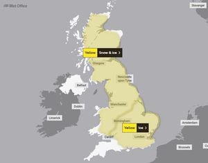
The Met Office has issued two separate warnings for much of the country, including the Black Country and Staffordshire, as temperatures remain around freezing.
Forecasters have said temperatures will feel like -6C tonight and will continue to feel sub-zero until Sunday morning, regularly feeling as cold as -5C at night, with early morning mist expected in places tomorrow morning.
In its forecast for tonight, the Met Office says: "Clear skies through much of the night again mean temperatures will plummet leading to a hard frost and some freezing fog patches. Northern parts perhaps turning cloudier towards dawn. Minimum temperature -7C.
Looking ahead to Friday, forecasters continue: "Some lingering freezing fog patches through the morning, though some sunny spells. Somewhat cloudier than on Thursday, especially in the north, and still feeling cold. Maximum temperature 3C."
With freezing temperatures set to remain for another few days, la severe cold weather alert has also been issued, which runs until midday on Sunday.
It means there is a "99 per cent probability of severe cold weather/icy conditions/heavy snow" between now and then.
In its alert, the Met Office says: "Widely cold or very cold at first with severe overnight frosts in places (especially over snow cover). A rapid transition to milder conditions is expected through Sunday. Low single figure maxima early in the period will likely be replaced by low-double digits (at least in the South) on Sunday."
Warmer weather is expected on Sunday, when temperatures in the region are expected to reach 9C before climbing further to 12C on Monday.
However, forecasters warn that a "band of snow" is expected across England as temperatures climb, before "readily turning to rain as the milder air feeds in from the southwest".
"There remains a degree of uncertainty regarding the extent of this snow. It should be noted that this may be a relatively short milder interlude with cold weather expected to return from the north next week," the alert added.
A yellow weather alert for ice is in place for Sunday morning from 3am-11am which includes much of the Midlands as well as southern and eastern England. The Black Country, Staffordshire, Worcestershire and Shropshire are all included in the alert, which says: "Widespread frozen surfaces ahead of a band of rain, sleet and snow, pushing northeast across the UK though Sunday, leads to a risk of icy conditions through the morning, before conditions turning much milder from the west.
"Any slight accumulations (of snow), likely no more than 1-2cm, and mostly over higher ground, will melt rapidly, which may briefly add to the ice risk. In addition to the ice and snow risk, strong winds are expected, mainly over higher ground."
The expected snow has led to a yellow weather warning for snow and ice across vast swathes of the country, including parts of Staffordshire and Shropshire, from 3am-9pm on Sunday.
Issuing the weather warning, the Met Office says: "A band of snow is expected to move northeast across the UK on Sunday, in most places lasting two to four hours before turning to rain."
Temporary accumulations of 1-3cm are expected at low levels, and perhaps locally 5-8cm across higher ground such as the Welsh mountains.
"In addition to the snow and ice, strong winds are expected across all parts, with gales or severe gales mainly across high ground. This will lead to blizzard conditions in some areas for a time," the warning added.