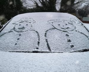
'Do not travel' warning as snow falls across Black Country and Staffordshire
A severe weather warning is in place as snow falls across the West Midlands - while riverside residents continue to battle flooding.
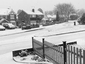
Snow arrived in large parts of the Black Country at around 8am on Sunday morning, with around three inches (8cm) building up by 9.30am in many areas.
By midday much of the region was covered in white, with road conditions dangerous and emergency services warning people to avoid travelling unless absolutely necessary.
The coronavirus testing centre at Engine Lane, Brierley Hill, has been closed as a result.

It comes as riverside residents in the region deal with serious flooding after the Severn and other rivers burst their banks in recent days.
A severe weather warning for snow covering the Black Country, Staffordshire and wider Midlands was issued by the Met Office for all of Sunday, with forecasters suggesting snow could fall throughout the day.
The Met Office predicted that everywhere would have at least some snow by the end of Sunday.
Snow follows flooding in West Midlands:
Council gritters have been out but many roads are in a dangerous condition, including the M54 where a car overturned at lunchtime and the M6 Toll which has some lanes closed due to the snow.
Paramedics, police and fire crews have also been busy responding to incidents on smaller roads, including in Wednesbury where officers were monitoring the snow-covered road at Steel Roundabout.
Meanwhile temperatures in the region are expeceted to drop to around -5C (23F) overnight, with frozen snow likely to cause further hazardous conditions.
Meteorologist Simon Partridge said:“ (The Midlands) is where we are going to see the snow lasting the longest.
“The band of snow that came through overnight stalled over the Midlands and will then track its way back over south-east England.
“Our main focus is that it is going to be a really cold night, particularly across central and southern parts of the UK – so the whole of Northern Ireland, all of Wales, most of the southern half of England from the Midlands and southwards.
He added: “Temperatures are expected to dip to between minus 4C (24.8F) and minus 6C (21.2F) quite widely tonight and where we get that snow lying in parts of the Midlands we could see one or two places where temperatures are as low as minus 10C (14F).”
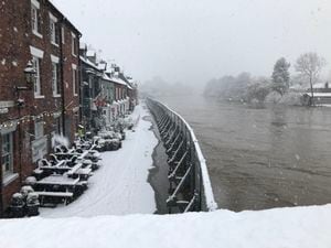
Along the River Severn, snow has been building up inches away from fields, gardens and roads that remain under water.
Flood warnings remain in place along the length of the River Severn, which peaked in Bewdley and Stourport on Sunday.
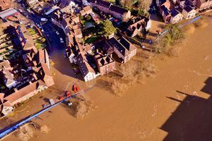
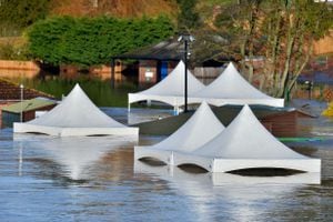
Many riverside areas remain submerged while residents in Bewdley are continuing the clean-up after the flood barriers in Beales Corner were breached on Friday night.
The River Severn is now receding but remains very high as home and business owners deal with the aftermath of the second serious flooding incident in less than 12 months.
The residents who were evacuated on Friday will now be returning to their homes to assess the damage.
The Severn peaked at 5.43 metres (14ft 101in) at Bewdley on Saturday - 13cm short of the record levels seen in 2000 and just short of the level reached lsat year.