When will the snow stop? Black Country forecast as weather warning remains in place
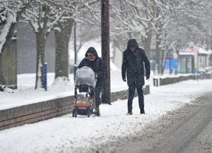
Schools are closed and buses are being diverted as snow continues to fall across the Black Country and Staffordshire.
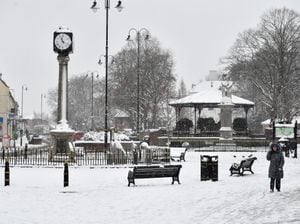
After the white stuff failed to stick for much of yesterday, more snowfall in the evening and overnight has given the county a very wintry look today.
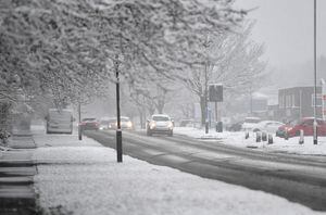
The region has been covered by a yellow weather warning from the Met Office this morning, and this is set to continue well into tomorrow.
The snow has affected much of the UK over the last 24 hours. The coldest March temperature in more than a decade was recorded overnight when -16C (3F) was recorded at Altnaharra in the Scottish Highlands. Met Office forecasters said this was also the lowest March temperature seen in the UK since 2010, when -18.6C (-1F) was recorded at Braemar in Aberdeenshire.
Nearer to home, the weather has forced several schools to close.
Here's a round-up of what weather warnings are in place across the region, and how long snow is forecast for. You can also get the latest updates on the effects of the snow here.
What weather warnings are in place?

Since 7am today a yellow warning for snow has been in place. This weather warning from the Met Office covers much of the UK, running from Herefordshire up to southern Scotland and covering the width of the country in-between. It remains in place until 2pm tomorrow.
In neighbouring Shropshire, that warning will be superseded between midday and 9am tomorrow by an amber weather warning for snow and ice.
What do the warnings say?
The Met Office's yellow weather warning for snow says: "An area of low pressure will move across the UK through today and Friday with snow continuing across Wales and central England this morning. Snow is expected to move slowly north during the day, becoming slow-moving across north Wales, northern England, Northern Ireland and southern Scotland during the afternoon and evening before slowly clearing southeast on Friday.
"Snow will likely turn to sleet or rain at times at lower elevations, especially in the south of the warning area, as well as near eastern coasts. At low levels including major cities such as Manchester, Liverpool and Newcastle accumulations are expected to be limited with a small chance of 2-5 cm falling.
"However, significant snow accumulations are possible over hills of northern England (including populated areas of South and West Yorkshire), Northern Ireland and southern Scotland. Here, 10-15 cm is expected quite widely above 100 metres, with a chance that 25-40 cm could fall in some places. Additionally, there is potential for strong winds, which may lead to blizzard conditions and drifting of lying snow."
Areas affected range from South Wales, between Brecon and Merthyr Tydfil up to Eyemouth in Scotland, south east of Edinburgh. As it covers the width of the country in between those two places, it means neighbouring counties such as Herefordshire, Worcestershire and Warwickshire - as well as Shropshire and Telford & Wrekin when they are not in their additional amber alert.
When will it stop snowing?
The Met Office forecasts that snow in the Black Country and further south in Staffordshire, such Wolverhampton, Dudley, Walsall and Cannock, will stop around lunchtime today. Some rain is expected at around 1pm and 3pm, before heavier rain is forecast from 6pm until midnight. Temperatures throughout are set to remain at 0C (32F). Further north in places such as Stafford, snow is due to continue falling until around 3pm when it slowly turns to rain. From 6pm until midnight, a mix of snow and rain is forecast to fall as temperatures hover at around 1C (34F).
All areas are then expected to have more snow falling between 4am and 5am up until 10am tomorrow.
At that point, it should then stop for good.
Met Office forecasts predict a cloudy afternoon, with temperatures reaching 4C (39F) and even the chance of a bit of sunshine in the afternoon. However, temperatures are set to dip overnight to to around -3C (27F), meaning any snow that's still on the ground come nightfall tomorrow could be very slippy come Saturday morning.
After that, temperatures are set to reach highs of 4C (39F) on Saturday and 12C (54C) on Sunday and Monday.