Possible 'flooding' predicted for West Midlands region this weekend in latest weather report
The Met Office has predicted possible "surface water flooding" in the West Midlands region this weekend.

While tomorrow is going to be a cool and cloudy day with the chance of a few showers, some of them heavy, it's not going to be too extreme with max temperatures still reaching 21C.
However, the outlook for Saturday to Monday is a bit of a different story.
While experts predict it was still feel warm when it's sunny, the weather is going to become increasingly unsettled with "heavy bands of rain slowly moving across the region and showers in-between."
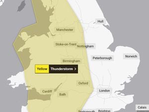
The Met Office has also warned of "possible surface water flooding in places" between Saturday and Monday.
According to gov.uk, "surface water flooding happens when rainwater does not drain away through the normal drainage systems or soak into the ground, but lies on or flows over the ground instead."
The longer term forecast for September also predicts thundery weather, with lots of rain interspersed with sunny periods. The rain will last longer at times bringing down temperatures.
During the second half of September, we're going to experience an "east-west split in conditions."
In the east (of the West Midlands), including parts of the Black Country, it's all about dry conditions and a fair bit of sunshine.
But western parts of the region, including parts of Shropshire, will experience "more rain and showers at times."
Temperatures are likely to remain average for the time of year for most of us, except during longer periods of rainfall.