Rain, sleet and snow for region as flood alerts remain in place
The region was hit by a band of rain, sleet and snow today as flood alerts remained in place, with river levels still high after Storm Christoph..
Alerts - meaning flooding is possible, be prepared - for areas along the River Severn in Worcestershire, and the Sow and the Penk in Staffordshire.
More than 70 flood warnings - meaning flooding is expected and immediate action is required - were reported across England this morning, along with over 200 flood alerts.
Walsall's League Two clash with Mansfield Town was today postponed due to a waterlogged pitch.
Meanwhile a snow warning that had been issued across much of western England for Saturday has been revised to cover a smaller area – the Met Office said that sleet could still turn to snow in Staffordshire or the Black Country.
Snow will mainly fall over high areas but could get down to lower levels. It is expected be drier and a little brighter in the afternoon.
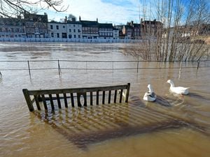
Water levels remain high at the river gauge at Bewdley, where flood barriers were breached last week.
The warning system said: "Flooding of roads and farmland is expected to continue. We expect flooding to affect low lying land and roads adjacent to the river from Highley to Tewkesbury."
The Government's flood warning for the Severn covers low-lying areas down the river near Bridgnorth, Highley, Bewdley and Worcester, as well as further up including Ironbridge and Shrewsbury.
The Met Office today also issued a further yellow warning for snow with a risk of widespread ice for Tuesday in the region.
See the Met Office's latest forecast here (no sound):
The national picture
Parts of England and Wales are braced for more wintry conditions, as a “messy mix” of weather warnings for snow, ice and rain remain in force.
The cold conditions will move further north into next week, with the potential for 20cm of snow in places before midweek, a Met Office forecaster has said.
Meteorologist Simon Partridge told PA: “We’ve got this band of rain sleet and snow that’s moving across much of England and Wales through today, that is a real messy mix.”
The picture varies across the country on Saturday, with much of Devon and Cornwall under a yellow warning for rain, with predictions that as much as 25mm could fall by the end of the day.
Other southern areas will also be wet, but further north sleet, rain and hill snow have triggered a further yellow weather warning.
“They’re just getting a cold, wet, miserable day really under that band there,” Mr Partridge said.
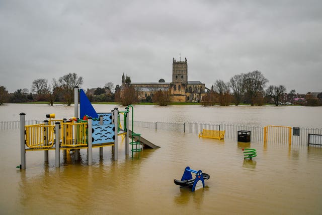
Pictures from Gloucestershire on Saturday morning showed a children’s playground partially submerged in Tewkesbury and vehicles driving through rising floodwaters in Lower Applerlay.
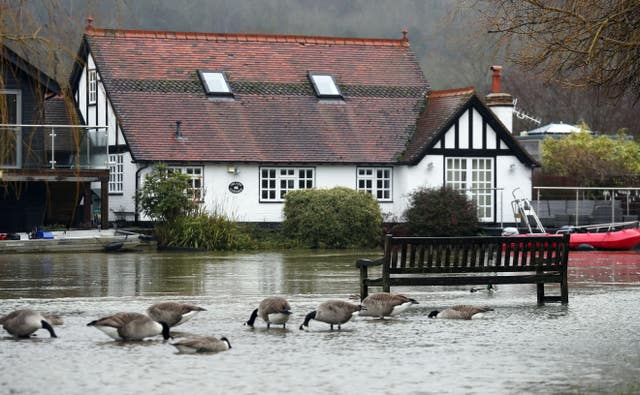
There were similar scenes in Henley on Thames in Oxfordshire, where water was seen rising on to the towpath, surrounding benches and approaching riverside homes.
As the rain and sleet moves away overnight, the risk of ice persists, with central England and Wales faced with a further yellow weather warning on Sunday.
Temperatures will drop as low as minus 6C overnight in England, and the potential for the mercury to fall to between minus 10C and minus 15C in parts of Scotland.
After more settled but chilly days on Monday and Tuesday, Mr Partridge said: “It gets a bit more interesting as we go into Tuesday and the middle of the week.”
He predicted a “much heavier” band of rain to arrive overnight on Monday into Tuesday which will “quickly turn to snow as it bumps up against cold air” and has triggered further yellow weather warnings for snow and ice.
Northern England and parts of Wales could see snow “pretty much anywhere” with 1cm to 5cm likely at lower levels and 5cm to 10cm possible in the hills.
The highest areas could get “up to 20cm or so though the course of the day” and Mr Partridge predicted that Trans-Pennine routes in particular could have some issues on Tuesday.
The same band of wintry weather will move northwards towards Wednesday and take the weather warnings for snow with it, with the central belt of Scotland most likely to see disruption.
“Not too bad, just messy in the south today, pretty good on Sunday and Monday, and then disruptive snow affecting northern parts of the UK” later in the week, Mr Partridge said.