These Nasa videos of Hurricane Irma show how terrifying it looks from above
The hurricane is the Atlantic’s most powerful in recorded history.
Hurricane Irma is headed for the Caribbean, just days after Hurricane Harvey struck Texas killing at least 65.
New videos released by Nasa, shot by one of its weather satellites, show the latest storm approaching the islands before it is expected to head to Florida.
You can see why officials in Antigua closed their warning message with “May God protect us all”.
It’s already the most powerful Atlantic Ocean storm in recorded history, with maximum winds of 185mph.
And over the last few days it was upgraded from a category four to a category five – the most severe.
Even Nasa’s starting to sound nervous.
This video shows the sun shining into the eye of the hurricane.
Weather satellite GOES-16 also picked up lightning strikes shown in yellow and red, around the storm’s centre.
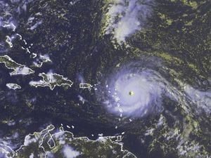
In this video, you can see Irma approaching the islands of the Caribbean, specifically Barbuda.
The largest island outline to the left is Puerto Rico.
They also picked up footage of the hurricane passing directly over the islands of Saint Martin and Anguilla.
Forget the science, this just looks apocalyptic.