Plans to slash historic Great Barr conservation area by 630 hectares thrown out
Plans to slash the Great Barr Conservation area by 80 per cent have been thrown out by Walsall Council.
Bosses are set to approve the decision to keep the boundary of the protected zone exactly as it is after a ‘clear majority view’ expressed during consultation.
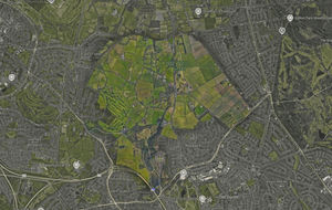
It follows a draft Great Barr Conservation Area Appraisal and Management Plan (CAAMP) produced last year which recommended reducing the 774 hectare site to just 144 hectares.
The review was broken down into four zones – A, B, C and D. The council had proposed to reduce the area to encompass only Area A, the ‘historic core’ of the Great Barr Estate.
Area A was the original boundary of the conservation area, first designated in 1976. It includes Great Barr Hall, The Lakes, Merrion’s Wood, Fox’s Plantation and Chapel Lane.
In 1996 the boundary was extended to include the surrounding agricultural landscape, areas now titled B, C and D.
Areas B, C and D cover the Great Barr Medieval Deer Park, Barr Beacon, Coxfold Farmhouse, Doe Bank Farm and several others.
During the consultation on whether to reduce the area to its original boundary, three out of four people said there should be no changes.
Reasons given included that reducing the boundary would lead to the development of the land for housing, loss of protection of green spaces, wildlife and historic sites, and destruction of nature and the character of the area.
Walsall Council said it has taken on board the concerns of local residents and decided to make no changes to the existing boundary of the conservation area.
Cabinet members will meet on Wednesday, December 10, to formally approve the decision.