'Hottest day of June' as West Midlands experiences more warm temperatures and highs of 33C
The West Midlands is bracing for more warm weather as many parts of the UK experience another heatwave.
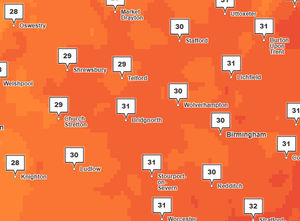
High temperatures are expected to continue across Walsall, Wolverhampton, Dudley and Sandwell as we enter the hottest day in June.
The weather group, the Met Office, has predicted temperatures of around 33C as many areas across the UK experience rising temperatures and possible highs of 34C.
Today is expected to be the hottest day of June for the West Midlands, with the Met Office expecting a breezy start to the day, before turning slightly cooler in the afternoon and highs of 17C tonight.

The latest forecast comes as many areas in the UK brace for another heatwave, with highs of 34C expected across many parts of central and eastern England.
Met Office meteorologist, Matthew Lenhert, said: "Temperatures will be higher still on Monday, with highs of 34C possible in central and eastern parts of England.
"This coincides with the end of Glastonbury with lots of people travelling home, and the start of Wimbledon so people should be prepared for some hot and humid conditions.
"Stay hydrated and try to keep out of the sun during the hottest part of the day."
It is expected to be slightly cooler in the week ahead, with highs of 28C expected on Tuesday with slight winds, and spells of rain, cloud and temperatures slightly above average between Wednesday and Friday.
The Met Office warned that it won't be hot everywhere, however, as those travelling to Northern Ireland or southern parts of Scotland may experience heavy rains and cloud.
See the full West Midlands forecast below:
Today:
A warm start to the day with plenty of sunshine for all. Feeling hot by the afternoon with temperatures well above the late-June average. Light winds, and mostly dry though a small chance of a shower later. Maximum temperature 33C.
Tonight:
Warm and humid with plenty of late sunshine. Remaining settled overnight though cloudier skies spilling in from the west may bring a few spots of rain and drizzle at times. Minimum temperature 17C.
Tuesday:
Cooler than recent days for many with cloudier skies bringing a few outbreaks of rain at times. Still rather warm in the far east. Winds remaining light. Maximum temperature 28C.
Outlook for Wednesday to Friday:
Fresher for all, with cloudier skies bringing spells of rain, these sometimes heavy on Wednesday and Thursday, but some drier, brighter intervals as well. Temperatures near or slightly above average.