Wolverhampton hit by mini-tornado?
We've been seeing some changeable weather over the past few days, from hot sunshine to torrential downpours. But could we have been hit by a mini-tornado in Wolverhampton?
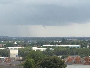
Twitter users seemed to think so with these images being tweeted this afternoon.
One image was taken from a train as it passed through Wolverhampton with another showing heavy cloud and the 'tornado' over rooftops.
Ian C Ashford also posted an image on Facebook showing the clouds above the skyline.
But although it may have looked menacing it was what is known as a 'funnel cloud.' These are not uncommon at this time of year and do not have the destructive potential of a tornado.
The Met Office website states a funnel cloud is 'a cone-shaped cloud which extends from the base of a cloud towards the ground without actually reaching the surface'.
Tornadoes do reach the ground and in a typical year the UK sees between 30 and 35.
The rain is set to continue through today with some brighter spells tomorrow, but temperatures will struggle to get any higher than around 16°C for the rest of the week.