Weather alert issued for West Midlands as thunder is on the way - here is when it may strike
A weather alert has been issued for the West Midlands as thunderstorms have been predicted to hit the county.
While Friday's weather remained sunny most of the day, with some clouds but temperatures above 25C Degrees, The Met Office say storms are on their way for the weekend.
According to the Met Office, Friday night going into Saturday morning will see a lot of cloud over the region with some "sudden" rain showers, while thunderstorms are predicted to hit the county at some point on Saturday.
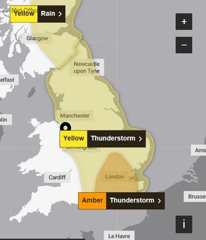
Issuing a Yellow Warning for thunderstorms for the West Midlands, a spokesperson for the MET Office said the thunderstorms may result in flash floods.
Meanwhile an amber weather warning was issued by the Met Office for London, parts of the south and south east of England from 4am to 11am on Saturday.
Speaking of the weather in the West Midlands the spokesperson said: "Heavy rain, with some thunderstorms, may lead to disruption in places on Friday night and through much of Saturday.
"Spray and sudden flooding could lead to difficult driving conditions and some road closures. Where flooding or lightning strikes occur, there is a chance of delays and some cancellations to train and bus services. Power cuts might occur and other services to some homes and businesses could be lost.
"Flooding of homes and businesses could happen quickly, with damage to some buildings from floodwater, lightning strikes, hail or strong winds.
"Fast flowing or deep floodwater is possible, causing a danger to lifeSome communities might become cut off if roads flood."
West Midlands Met Office weather forecast
Today:
Widely cloudy with frequent, heavy downpours of rain, and more prolonged periods bringing the risk of thunderstorms and hail. Some drier, brighter breaks possible later in the afternoon. Maximum temperature 24 °C.
Tonight:
Heavy showers and thunderstorms continuing to spread northwards, easing into the night before turning cloudier from the south by dawn with further spells of rain. Feeling muggy. Minimum temperature 16 °C.
Sunday:
Remaining unsettled with heavy showers, thunderstorms or longer spells of rain throughout the day. Breezy, especially in and around any intense downpours. Maximum temperature 23 °C.
Outlook for Monday to Wednesday:
Staying largely unsettled with outbreaks of rain, or heavy, thundery downpours through the week. Warm in any sunny spells that do develop and often breezy.