Maps show where thundery showers could hit West Midlands as warnings issued
Met Office maps show how heavy, thundery showers could move across the West Midlands this week, as the forecaster issues thunderstorm warnings for the region.
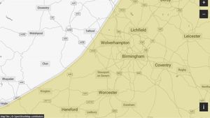
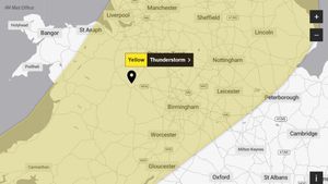
A Met Office yellow thunderstorm warning will be in place for parts of Shropshire, Herefordshire, Staffordshire, Warwickshire, the West Midlands Conurbation and Worcestershire from 11:00 to 20:00 on September 3.
The warning reads: “Thunderstorms associated with scattered heavy showers may cause some impacts during Wednesday.
“There is a good chance driving conditions will be affected by spray, standing water and/or hail, leading to longer journey times by car and bus. Probably some damage to a few buildings and structures from strong winds and/or lightning strikes. Delays to train services are possible. Some short term loss of power and other services is likely. There is a small chance that a few properties could become flooded.
“Scattered heavy showers, some with thunder, are expected to develop later this morning and into the afternoon, before easing this evening. In the most active storms, hail, strong gusty winds, and lightning may be impactful. There is also a chance that a few spots could see frequent, heavy bursts of rain, leading to surface water flooding.”
Another yellow thunderstorm warning will be in place for Shropshire, Staffordshire, Stoke-on-Trent, Telford and Wrekin, Warwickshire, the West Midlands Conurbation, Worcestershire from 02:00 to 17:00 on September 4.
The warning reads: “An area of heavy showers and thunderstorms, moving northeast, may cause some localised flooding.
“Spray and sudden flooding could lead to difficult driving conditions and some road closures. Where flooding or lightning strikes occur, there is a chance of delays and some cancellations to train and bus services. There is a slight chance that power cuts could occur and other services to some homes and businesses could be lost. There is a small chance that homes and businesses could be flooded quickly, with damage to some buildings from floodwater, lightning strikes, hail or strong winds.
“Bands of heavy showers and thunderstorms are expected to move northeast across parts of England and Wales on Thursday. As showers progress northeastward they will become temporarily slow moving, leading to an increased chance of surface water flooding.
“Whilst the vast majority of places will have either non-impactful rain or remain dry, a few places within this area could see 30-60mm in an hour. Hail and lightning will be additional, possibly locally impactful, hazards.”