West Midlands Heatwave: How hot is it expected to be and when will the scorching weather end?
Temperatures in the West Midlands are expected to rise steadily over the coming days amid the third heatwave this year.
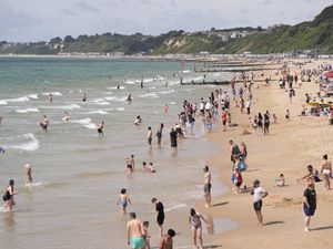
The weather has warmed up again in the West Midlands as the UK endures its third heatwave this year and the Met Office has extended an amber heat alert across parts of England, including the West Midlands.
The UK Health Security Agency’s (UKHSA’s) latest heat health warning comes as hot and dry weather scorches England, with temperatures set to rise further over the weekend.
The alert comes into effect at 12pm on Friday and covers the East Midlands, West Midlands, South East, South West, East of England and London until 9am on Monday, following two other amber alerts issued in consecutive weeks at the end of June amid two separate heatwaves.
The third potential heatwave comes as temperatures continue to steadily rise across Wolverhampton, Walsall, Dudley and Sandwell, with water company Severn Trent urging residents to be mindful of 'water waste', to avoid possible hosepipe bans.
The Met Office has predicted temperatures will climb into the low 30s over this weekend, saying that the heat is expected to last until 'early next week'.
However, while temperatures are expected to reach highs of 32C on Saturday (July 12) in parts of England and Wales including the West Midlands, the Met Office said that conditions 'are not expected' to be as high as that at the end of June and early July.
The alerts warn of the potential for a rise in deaths, particularly among those aged 65 and over, or with health conditions, because of the heat.
The risk description reads:
There is potential for severe impacts across health and social care services due to the high temperatures, including:
Increased risk to life across the whole population, with significant impacts on older people
Significantly increased demand on all health and social care services
The heat affecting the ability of the workforce to deliver services
Hot indoor environments making provision of care challenging and national critical infrastructure failures, such as generators and power outages
How hot is the West Midlands weather expected to get?

Temperatures are expected to break into the low 30s over the coming weekend, with conditions today expecting to see a high of 32C in the West Midlands.
Saturday on the other hand is expected to see peak temperatures of 33C, with the weekend expected to feature very warm and humid weather, before turning muggy by night.
Temperatures are expected to continue to build as the days go on, pushing the West Midlands and the wider UK closer towards another heatwave.
When is the heat expected to end in the West Midlands?
Predictions indicate that temperatures will begin to dip in the West Midlands early next week, with the Met Office saying that there are 'signs' of less hot and fresher conditions.
The forecaster said that cooler conditions will arrive from the west in the week ahead, however, how quickly they will arrive 'is uncertain'.
See the full West Midlands weather forecast from the Met Office below:
Today:
Early morning mist and fog soon burning away to leave a dry and fine day. Plenty of sunshine, this turning a little hazy into the afternoon, and light winds for all. Very warm or hot. Maximum temperature 32 °C.
Tonight:
After lengthy spells of late evening sunshine, a clear, settled night to some. Feeling muggy for all with light winds and some mist and fog patches returning to rural spots. Minimum temperature 16 °C.
Saturday:
Dry, sunny, and hot with any early mist soon burning away, and lengthy spells of sunshine throughout the day, this turning hazy into the afternoon. Maximum temperature 33 °C.
Outlook for Sunday to Tuesday:
Slightly cooler on Sunday, though still widely warm and dry with sunny spells. Cloudier and fresher on Monday and Tuesday with showers and perhaps thunderstorms arriving from the south.