Man found dead after tree falls on caravan during Storm Goretti
The incident took place in the Mawgan area of Helston, Cornwall.
A man has been found dead after a tree fell on to a caravan as weather warnings remain in place after Storm Goretti hit the UK.
Devon and Cornwall Police said emergency services were called at around 7.35pm on Thursday to the Mawgan area of Helston where work took place on Friday to remove the tree.
A man in his 50s was found dead within the vehicle.
His death is not being treated as suspicious and his next of kin have been informed, police said.
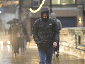
The storm brought winds of almost 100mph after forecasters issued a rare red warning for “dangerous, stormy” winds in the South West.”

About 27,000 properties were without power in the South West at 9am on Saturday, according to the National Grid’s website, along with close to 2,300 in the West Midlands and about 300 in the East Midlands, while all power has been restored in Wales.
Downing Street said support was being offered to homes left without power.
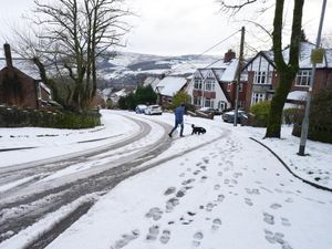
Yellow warnings for snow and ice remain in force until Sunday and rail disruption may be seen through the weekend across England, Wales and Scotland, National Rail said.
Forecasters warned that the combination of melting snow and rain will increase the flood risk for some in the coming days.
Some 15cm of snow was recorded at Lake Vyrnwy in Powys and 7cm at Preston Montford in Shropshire and Nottingham.
In Scotland, there was 27cm at Altnaharra in Sutherland, 26cm at Loch Glascarnoch and 22cm at Durris in Kincardineshire.
A yellow warning for snow and ice is in place until 3pm on Saturday, with further snowfall possible across parts of northern England and much of Scotland, while a widespread risk of ice is expected to cause disruption.
Within the alert area, between 2-5cm of snow is likely to accumulate on hills above 100m with up to 15cm possible in areas above 300m in parts of central and eastern Scotland, according to the Met Office.
A separate yellow warning for ice covers large parts of England and Wales until midday on Saturday as partially thawed snow refreezes, accompanied by wintry showers and freezing fog.
In Northern Ireland, a yellow warning for snow and ice will run until 11am on Saturday, with the Met Office warning of icy patches and some hill snow.
A yellow warning for snow and ice will be in force for much of Scotland, the East and West Midlands, north-east and north-west England and Yorkshire from 2am until 3pm on Sunday.
A further 2-5cm of snow is likely in the warning area, with 10-20cm possible above 200 metres.
The Met Office has advised those within the regions covered by alerts to prepare for delays to journeys which could involve dangerous driving conditions and to take extra time when travelling to help avoid slips and falls on the ice.
Seven Football League matches were postponed in England and another seven in Scotland because of Storm Goretti, while the racing at Warwick was also called off over the weekend.
Craig Snell, Met Office forecaster, said Saturday would provide a “bit of respite” across the UK as the storm moves away – despite a few “wintry showers”, particularly in Scotland.
Of the new weather system approaching the country, Mr Snell said this is expected to start in parts of Northern Ireland on Saturday evening, travelling across into Scotland and northern England.
He added: “It will bump up into the cold air and turn to snow again, but this time it is coming in with some milder air so it will transition back to rain for some of us as we go through the course of the night and into tomorrow and that again could lead to some problems with ice so we already have warnings out ahead of that.
“This time the milder air will eventually win the day and it will herald a very different flavour of weather for all of us as we go into next week, but it’s going to be a very kind of messy transition.
“So yes, we are expecting some further impacts tomorrow,” the forecaster said on Saturday.
Conditions on Sunday are expected to be “wet and windy” in the southern half of the UK, but with gusts “nowhere near as strong as they were for Goretti,” he added.
However, some gales may still hit the coastlands, Mr Snell said, adding that this was not uncommon for the time of year.
Next week, the UK “will be saying goodbye to the really cold weather”, with temperatures of between 9C and 11C expected in the south and around 6C to 8C in the north, the forecaster said.