Snow, ice and potential gale-force winds forecast at start of new year
A yellow weather warning has been issued for large parts of Scotland, but temperatures are expected to fall elsewhere too.
Snow and gale-force winds could batter northern parts of the UK at the start of the new year, forecasters have said.
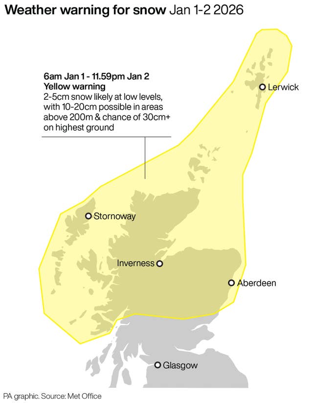
A yellow warning for snow and ice has been issued for parts of Scotland north of the central belt from 6am on New Year’s Day until midnight on January 2.
Strong, potentially gale-force northerly winds will also batter those in the warning zone, the Met Office said.
Around 10cm snow is expected to have accumulated in some areas by Friday morning, reaching up to 30cm on the highest roads and hills.
Meanwhile, amber cold health alerts have been issued for the North East and North West of England, which are due to remain in place until noon on January 5, with temperatures expected to fall to 3-5C.
New Year’s Eve will be largely settled for many but winds and showers will pick up in Scotland. Temperatures are then set to drop at the turn of the year.
The Met Office said in its yellow warning: “Given the strength of the wind, some significant drifting of snow is likely. Lightning may well be an additional hazard.”
Passengers and vehicles could become stranded, transport could be delayed and cancelled, and some rural communities may be cut off, the forecaster said.

Senior Met Office press officer Georgie Myers said: “It’s going to be a cold start to the new year and we’ve got a snow and ice warning issued, so there’s going to be a transition to much more unsettled and wintry conditions into the new year.
“High pressure is going to be in charge for the next few days, so there’s going to be a continuation of the chilly but settled conditions.”
Yellow cold health alerts have been issued by the UK Health Security Agency (UKHSA) for London and the East, South East and South West of England, as well as the East and West Midlands and Yorkshire and the Humber.
UKHSA, which also issued the amber alert, said it means the weather is “likely” to cause significant impacts across health and social care services, including a “rise in deaths” among those with health conditions or aged 65 or over.
Met Office deputy chief forecaster Mark Sidaway said: “It certainly looks like we are in for a taste of ‘winter’ as we welcome in the new year, initially in the north but more widely across the UK for the first week of 2026.
“Arctic air and strong northerly winds will bring cold or very cold conditions to all parts of the UK, and it will feel especially cold in the strong winds.
“Widespread and locally severe frosts are expected, along with the first snow of the winter for many.
“These colder conditions and wintry hazards – snow, ice and strong winds – will develop more widely as we enter the new year, with more warnings for snow and ice likely.
“It looks like this cold spell will last through at least the first week of January, so it’s important people keep up to date with the latest forecast and warnings.”