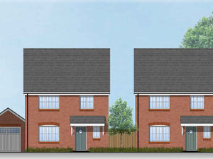
73 new homes approved for South Staffordshire field - despite flooding concerns
Councillors have given the green light for more than 70 new homes to be built on farmland on the edge of Brewood despite flooding concerns.
The land off Four Ashes Road, which has recently been used for grazing cattle, has previously been earmarked for a housing development by South Staffordshire District Council.
On Tuesday (January 28), the council’s planning committee unanimously approved a full application for 73 homes, alongside drainage, landscape and public open space details. A vehicle access is proposed off Four Ashes Road and there will also be a pedestrian link footpath between the site and the Stonebridge Estate.
The properties will include 30 affordable homes, a report to the planning committee said. There will be six bungalows and two ground floor apartments, but this falls short of a requirement for 10% of homes to be bungalow provision.
The council received 34 objections to the proposals. Concerns raised included pressure on existing services, safety of access and flood risk.
Emma Pittwood, who spoke against the proposal at Tuesday’s meeting, said: “It will place extra strain on the schools that are already nearly at capacity. You can’t get an appointment at the doctors’ surgery for love nor money – and at the moment there’s no access to the doctors’ surgery because the bridge on Kiddemore Green is closed to access because part of it has collapsed.

“We don’t have a dentist and we don’t have an optician in the village – the closest are in Codsall and there is no bus from Brewood to Codsall any more, so you would have to get a taxi and not everyone can afford that. The two remaining village shops are the Co-op and Stars; this is not enough in order to sustain a family.
“If you want shopping you are going to have to go to Cannock, Wolverhampton or Penkridge to get your food shopping. You’re going to have to rely on bus transport and the bus transport is not reliable to an extent I’m satisfied with.
“The additional traffic will lead to potential RTCs (road traffic collisions), especially down at Claygates Road. We have seen in the last six months two cars have gone down the Claygates Road into John Groves’ field and they’ve gone through the bridge.
“I live near the site and it is flood plain – there’s a very high water table, it regularly floods and at the moment it is flooded. It does not drain properly and we are not satisfied the drainage plans in place are sufficient to deal with this.”
But agent Neil Cox, who spoke in support of the proposals, said: “In respect of flood risk, the applicant has provided a flood risk assessment and a sustainable drainage strategy. Additionally, the flood risk assessment has been fully reviewed by flood modelling experts to provide further consideration of the implications to the Chillington Brook – this concludes the proposal results in no reduction of flood plain capacity or flood plain conveyance and the development will not adversely impact the flood risk of properties up or downstream of the site.
“The proposals will deliver much-needed market and affordable homes to address the council’s increased housing needs and current lack of five year housing land supply, which stands at just 0.87 years. A local connection requirement will also be secured through legal agreement to give preference to those in need of an affordable home locally.”
“The proposed development, located in the main service village is for 73 high quality homes; 40% of which will be provided as affordable housing. Access to the proposed development will be via a new priority junction with Four Ashes Road.
“The site was identified as safeguarded land through the SAD (Site Allocations Document) and removed from the Green Belt in 2018 to meet longer-term housing needs. The application site represents a proposed application for a minimum of 63 homes in the emerging Local Plan, currently at examination in public.
“The proposal before committee is the result of extensive consultative work with technical consultees, local councillors and the community. the parish council and Brewood Civic Society both support the proposal.”
Ward councillors Diane Holmes and Wendy Sutton highlighted existing flooding issues in the area at Tuesday’s meeting. Fellow ward councillor Susan Szalapski had previously objected to the development on flooding grounds and because of concerns about potential “crime through design” relating to the pedestrian footpath.
Councillor Sutton said on Tuesday: “We’ve had long conversations about this development and how it can best accommodate the needs of the residents of Brewood. Sadly the lack of bungalow provision, as opposed to ground level apartments which appear on these plans, doesn’t sit with the priority of the parish – we need low-level as in bungalows, not apartments for this area.
“Flooding is a huge concern – the field has on a very regular basis and is currently under water. I still have concerns, but in view of the fact that experts and so many drainage people have looked at this and done so much work, I cannot see a reason to object to this application on flooding grounds.”