Snow warning issued for West Midlands - where and when warning will come into force
Watch the Met Office forecast, as a snow warning is issued for the West Midlands.
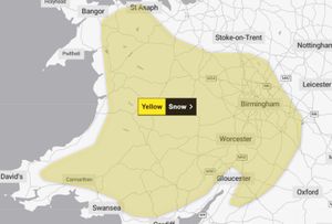
The Met office has issued a snow warning for parts of the West Midlands, with delays to road, rail and air travel possible.
A yellow warning for snow will be in place for the West Midlands (excluding Stoke-on-Trent) from 16:00 on Wednesday February 18 to 06:00 on Thursday February 19.
The warning - which has a very low likelihood and a medium impact - reads: “A period of snow could bring some disruption to parts of Wales and central England later Wednesday and overnight into Thursday.
“There is a small chance of travel delays on roads with some stranded vehicles and passengers, along with delayed or cancelled rail and air travel. There is a slight chance that some rural communities could become cut off. There is a small chance that power cuts will occur and other services, such as mobile phone coverage, may be affected.
“Whilst there is some uncertainty in the details, there is the potential for an area of rain and snow to affect parts of Wales and central England later on Wednesday and overnight into Thursday.
“2-5 cm of snow could accumulate quite widely above 150-200 metres, with perhaps as much as 10-15 cm above 250-300 metres in mid and southeast Wales, as well as Herefordshire and Shropshire. Some small accumulations of snow, typically less than 2 cm, are possible to lower elevations, especially from later Wednesday evening into the early hours of Thursday morning.
“Strong east to northeasterly winds will accompany the wet weather, which could exacerbate impacts in places.”
Met Office West Midlands weather forecast
Tuesday February 17 day
The morning will get off to a frosty start with icy patches possible, though a fine day is in prospect. It will remain dry with plenty of sunshine, and the wind will fall light too. Feeling rather chilly though. Maximum temperature 6 °C.
Tuesday February 17 night
The dry theme will continue overnight. There will be clear periods at first, and although cloud will gradually increase, with a southeasterly breeze developing, some frost is still likely. Minimum temperature -2 °C.
Wednesday February 18
Bright intervals initially on Wednesday, but much of the day looks cloudy with a chilly, blustery southeasterly wind. During the afternoon some rain and snow is possible in the south. Maximum temperature 5 °C.
Outlook for Thursday February 19 to Saturday February 21
Overnight rain and snow will clear to leave a sunny but chilly day on Thursday, with lighter winds. Milder on Friday and Saturday, though some rain, and becoming windy again.