'Be prepared': See the full list of West Midlands flood alerts in place as 'persistent' rain expected this week
West Midlands residents are urged to 'be prepared' as 'persistent' rain is expected over the next few days.
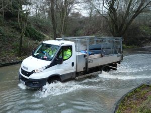
Several flood alerts have been put into place for rivers and lakes across the West Midlands.
The advice comes as the Met Office predicts light to heavy rain over the next four days, with sleet and rain also anticipated later in the week with the Environment Agency website warning 'flooding is possible - be prepared'.
Get the latest headlines delivered straight to your inbox with the Express & Star’s free newsletter

The Environment Agency website read: "Flooding is possible - be prepared. High river levels this morning may lead to flooding.
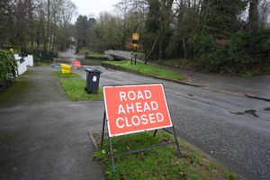
"Locations most affected will be low-lying land and roads near rivers. We are closely monitoring the situation. Take care and avoid walking, cycling or driving through flood water."
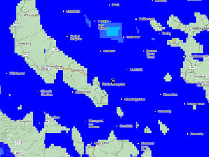
Seven flood alerts due to high river levels have been implemented by the Environment Agency (EA), with the authority warning that flooding is possible in each affected area.
Wednesday, Thursday and Friday will see high chances of heavy to light rain throughout the day and night, with Tuesday expected to see at least 15-30mm alone.

Higher locations across the country are expected to see 40-60mm of rain according to the Met Office, creating a flood risk to low-lying land and roads near rivers.
Senior operational meteorologist for the EA, Simon Partridge, said: “The weather is set to remain unsettled throughout the remainder of the week with further spells of wet and windy weather for many areas of the UK.
“With so much rain having already fallen over parts of the UK this year, many areas are sensitive to further rainfall. Therefore, further rainfall warnings are likely as the week progresses.
“There is currently no sign of any prolonged dry weather for the next seven to 10 days.”
Among the rivers to be included in the latest round of flood alerts are Bourne Brook in Tamworth and the River Sow and River Penk in Staffordshire, with both experiencing higher river levels today, which may lead to flooding.
See the full list of West Midlands rivers that are included in the flood alerts below:
Bourne Brook (Tamworth)
Lower Tame
Middle Avon Rugby to Bidford
River Arrow and River Alne
River Leam and River Itchen
River Sow and River Penk
River Sow, River Sherbourne, Canley Brook and Finham Brook.
The Met Office's long-range weather forecast expects brighter spells for much of the country starting on Saturday, February 14, with some colder conditions making a return, before turning milder for many.
The Met Office said: "After a brief quieter spell, associated with some colder conditions, Atlantic frontal zones look to make a return near the start of this period.
"The track of these depressions may be a little further north than over the preceding weeks, but will continue to bring broadly unsettled weather to many areas, with further spells of rain and perhaps strong winds at times.
"With the westerly influence, it should become somewhat milder for many, though there remains the chance that colder conditions could affect northern and northeastern parts from time to time."
See the full West Midlands weather forecast for the week ahead below:
Today:
It will be a murky start for most, with patchy mist or fog and drizzle in places. Often cloudy, but some brighter breaks possible through the middle of the day, ahead of more persistent rain arriving by late afternoon. Maximum temperature 10 °C.
Tonight:
Turning drier from the south through the evening, but murky again with hill fog. Further rain then edges northeast towards morning. Another mild night for all. Minimum temperature 4 °C.
Wednesday:
A cloudy, murky and wet start to the day. Rain will slowly clear north through the afternoon, bringing a mostly dry end to the day. Light winds and mild. Maximum temperature 11 °C.
Outlook for Thursday to Saturday:
Turning colder and drier as we head into the weekend. Further rain or showers through Thursday, less so on Friday. Saturday will be mostly dry, bright and chilly.