Flood warnings and alerts staying in place across Black Country and Staffordshire as region feels effects of Storm Chandra
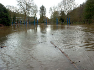
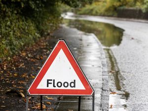
The after effects of Storm Chandra are being felt across the region as a number of flood warnings and alerts have remained in place.
Two flood warnings are in place near Halesowen, while eight flood alerts have been put up by the Government flooding service for areas across the Black Country and Staffordshire.
Residents living near Illey Brook at Halesowen have been warned to expect possible flooding after the water level of 0.90 metres was passed, with properties and roads around Chadbury Road and Woodman Close expected to be affected.
The Flooding Service said: "High river levels are expected to cause flooding today.
"Flooding may affect properties and roads around Chadbury Road and Woodman Close.
"We are closely monitoring the situation. Start acting on your flood plan if you have one.
"The Illey Brook level at Halesowen Manor Way was 0.95 metres. Property flooding is possible when it goes above 0.90 metres."
A second warning in Halesowen was put up for Lutley Gutter at Halesowen. with the River Stour level at Halesowen Dogkennel Lane at 0.46 metres and the Flooding Service said property flooding is possible when it goes above 1.05 metres.
The Flooding Service said: "Rising river levels are expected to cause flooding today.
"Flooding may affect properties around Clancey Way and Belle Vale.
"We are monitoring rainfall and river levels at the Dog Kennel Lane river gauge.
"The River Stour level at Halesowen Dogkennel Lane was 0.46 metres. Property flooding is possible when it goes above 1.05 metres."
The alerts have been put in place at Bourne Brook (Tamworth), which covers Shenstone, at River Blythe in Warwickshire, which covers the area near Birmingham Airport, River Rea, which runs through central Birmingham, River Sow and River Penk, River Stour and Smestow Brook in the Black Country and South Staffordshire, Upper Tame, Upper Tame at Sandwell Valley and Brooks in the Wyre Forest,
The Flood Service said the alert would remain in place at Bourne Brook (Tamworth) and Upper Tame at Sandwell Valley until 8am on Wednesday, while the other alerts would remain in place until 11am on Wednesday or as the situation changes.
For Bourne Brook (Tamworth), Flooding may affect low-lying land and roads adjacent to the Bourne Brook, while for River Blythe in Warwickshire, flooding may affect low-lying land and roads adjacent to the River Blythe between Cheswick Green and Blyth End.
For River Rea, flooding may affect low-lying land and roads adjacent to the River Rea between Longbridge and Nechells including Northfield, Kings Norton, Lifford, Stirchley, Selly Park and Digbeth, while for River Sow and River Penk, flooding may affect low-lying land and roads adjacent to the River Sow between Great Bridgeford and Shugborough, the River Penk between Coven and Stafford, the Sandyford Brook, the Rising Brook, the Ridings Brook and the Saredon Brook.
For River Stour and Smestow Brook, flooding may affect low lying land and roads around Halesowen, Stourbridge, Wombourne, Kingswinford and Kinver and for Upper Tame, flooding may affect low-lying land and roads adjacent to the River Tame between Horseley Heath and Castle Vale and the Ford Brook between Walsall and Bescot.
Finally, for Brooks in the Wyre Forest, flooding may affect low lying land and roads adjacent to the river from Acton Round to Noutards Green. Other locations that may be affected include Morville, Eardington, Highley, Wribbenhall and Rock.