Ice warning in place as West Midlands residents urged to take care following Storm Goretti snowfall
West Midlands residents have been urged to be cautious with a yellow weather warning for ice covering the region following widespread snowfall from Storm Goretti.
While there was no futher snowfall overnight, dropping temperatures left widespread ice across the West Midlands on Saturday morning (January 10).
The Met Office has issued a yellow warning for ice, urging residents to take care amid potentially treacherous conditions.
Tens of thousands of people across the country are still said to be without power after Storm Goretti - including more than 1,500 across the West Midlands.

The Met Office warnings, which include the potential for more snow in parts of the UK - although not the West Midlands - remain in place until Sunday and rail disruption may be seen through the weekend across England, Wales and Scotland, National Rail said.
Nearly 1,700 West Midlands properties were still without power at 6am today, according to National Grid's website, while there were 28,000 in the South West and another 150 in the East Midlands.
All power has been restored in Wales according to reports.
Downing Street said support was being offered to homes left without power.
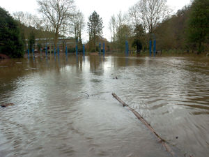
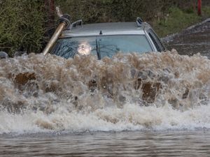
Meanwhile forecasters have warned that the combination of melting snow and rain will increase the flood risk for some in the coming days.
Forecasters recorded 15cm of snow at Lake Vyrnwy in Powys and 7cm at Preston Montford in Shropshire.
In Scotland, there was 27cm at Altnaharra in Sutherland, 26cm at Loch Glascarnoch and 22cm at Durris in Kincardineshire.
The highest rainfall total was recorded in Cornwall, with 61.8mm at Colliford Dam, followed by 57mm at Ddolwen Bridge, Dyfed, and 54mm at White Barrow in Devon.
A yellow warning for snow and ice covering Scotland and the north of England lis in place until 3pm on Saturday, with further snowfall possible across parts of northern England and much of Scotland, while widespread risk of ice is expected to cause disruption.
The Met Office said: "Partially thawed snow refreezing, accompanied by freezing fog and a few wintry showers, will bring the risk of ice overnight into Saturday."
It added: "Partially thawed snow during Friday will likely freeze overnight as temperatures fall below freezing, leading to a widespread ice risk.
"In addition, wintry showers will continue to feed into parts of Wales and southwest England at times, perhaps also into the West Midlands.
"Whilst there is some uncertainty as to the extent of any precipitation, this falling onto frozen surfaces may also add to the risk of ice. Freezing fog patches are also likely in places, posing an additional ice hazard."
It urged people to be cautious as they head out and about.
It added: "Keep yourself and your family safe when it is icy. Plan to leave the house at least five minutes earlier than normal.
"Not needing to rush, reduces your risk of accidents, slips, and falls.If you need to make a journey on foot, try to use pavements along main roads which are likely to be less slippery.
"Similarly, if cycling, try and stick to main roads which are more likely to have been treated.
"Give yourself the best chance of avoiding delays by checking road conditions if driving, or bus and train timetables, amending your travel plans if necessary."