Met Office issues fresh weather warning for West Midlands as Storm Goretti expected to bring 'heavy snow' to region - latest details here
The Met Office has issued a fresh weather warning for the West Midlands as experts predict Storm Goretti will bring another round of heavy snow.
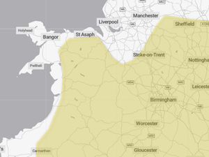
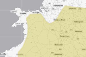
A yellow weather warning has been issued for Thursday and Friday this week as the Met Office predict more snow is on its way to the West Midlands.
The warning, which covers the majority of Shropshire and the Black Country, comes as the UK prepares for Storm Goretti, a weather system named by Meteo France.
Experts at the Met Office say that there is a potential for up to 20cms of snow in some places, especially over a higher ground.
A spokesperson for the organisation said: "A deep area of low pressure will move across the south of the UK during Thursday and into Friday bringing a mixture of rain, snow and strong winds.
"A spell of heavy snow is likely to develop over higher ground in south Wales later on Thursday before rain turns to snow more widely over parts of England and Wales during Thursday night.
"In some areas, 5 to 10 cm of snow may settle with the potential for up to 20 cm in some locations, especially over higher ground.
"Strong winds may lead to some drifting of snow. Rain and snow will then clear eastwards during Friday.
"This system has been named by Meteo France as the strongest winds associated with Storm Goretti are most likely over northern France."
For the latest school closure updates for the West Midlands check here.
For school closures in Shropshire check here
Latest Met Office weather forecast for the West Midlands
Today:
A mostly dry day, though often rather cloudy. Some brighter breaks are possible, mainly in the south. A few light wintry showers are possible. Tending to cloud over by late afternoon. Breezy and feeling cold once more. Maximum temperature 4 °C.
Tonight:
A band of rain sleet and hill snow will move eastwards across the region through the evening, clearing during the early hours. Icy stretches developing where skies clear later. Minimum temperature -2 °C.
Wednesday:
Another cold day is expected, with rather cloudy skies. A scattering of sleet and snow showers, these tending to ease later in the day. Gusty winds. Maximum temperature 5 °C.
Outlook for Thursday to Saturday:
Most likely dry initially on Thursday. Then an increasing risk of heavy rain, sleet and snow, along with strong winds, which may linger into Friday. Sunshine and wintry showers Saturday.