Severe rainfall warning as Storm Claudia arrives in West Midlands and Met Office issues weather warnings with wind gusts of 47mph forecast - here's when and where
The Met Office has issued an Amber weather warning for parts of the West Midlands as Storm Claudia heads to the UK
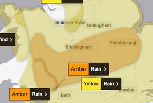
Flooding could hit the West Midlands today (Friday, November 14), with forecasters at the Met Office issuing amber and yellow weather warnings for severe rainfall and wind gusts of 47mph in the region.
Storm Claudia, which was named by the Spanish meteorological service, has brought heavy downpours and strong winds for much of the UK.
Some areas could see up to 80mm of rain, with deep floodwater causing a danger to life.
A yellow weather wawrning is currently in place across the West Midlands for heavy rain until 6am on Saturday - this is for most of the West Midlands and Shropshire and is rated as 'medium to low impact'.
But there is also an amber weather warning in place from midday to midnight today (Friday, November 14) for the West Midlands Conurbation, Staffordshire, Shropshire, Worcestershire, Herefordshire and Powys.
This warning is rated as Medium impact and medium likelihood of heavy rain leading to flooding and disruption and covers parts of the West Midlands including Birmingham, Kidderminster and Stourport.
It also covers parts of Wales, the East Midlands, South West, South East and East of England.
The Met Office said the weather may lead to power cuts, travel disruption and damage to buildings.
Those travelling are urged to be cautious.
Met Office chief meteorologist Matthew Lehnert said: “Storm Claudia will bring very heavy rainfall to a large swathe of central and southern England and Wales on Friday into Saturday.
“This rain will become slow moving and some areas could see up to a month’s worth of rain in 24 hours.
“Much of this will fall on saturated ground, increasing the chances of flooding and contributing to the amber warnings we have issued.
“Within the amber warning areas, some could see in excess of 150mm accumulate during the event, with 60-80mm fairly widely.
“Gusty winds in the north-west of England and north-west Wales is an additional hazard, with 60-70mph gusts possible in exposed places within the warning area.”
Here's the latest five day Met Office weather forecast for the West Midlands
Today:
Storm Claudia a wet and windy day. Rain turning persistent and heavy for all, leading to a risk of flooding and challenging driving conditions. Very windy too, with gales possible over the hills. Feeling cold. Maximum temperature 10 °C.
Tonight:
The wind and rain continuing for much of the night though heavier spells of rain easing by the morning. A chilly night ahead. Minimum temperature 5 °C.
Saturday:
Spots of rain to start but turning drier later. Often cloudy. Windy to start though any strong, gusty winds easing. Another cold day. Maximum temperature 10 °C.
Outlook for Sunday to Tuesday:
Brighter from Sunday but notably colder in northerly winds, with overnight frosts possible. A chance of more cloud around on Tuesday.