West Midlands region braced for flooding and snowfall
The West Midlands is braced for further flooding and more snow this weekend – with a severe weather warning issued for the region.
The Met Office warned that a snow alert is in place on Saturday for a huge area including the West Midlands, Staffordshire, Worcestershire, much of Wales and as far south as Oxford.
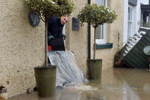
And today flooding is possible again near the River Severn after torrential rain hit the area last night. One area at risk is Bewdley, where last week the force of the water meant flood barriers were breached.
The Government's flood warning for the Severn covers low-lying areas down the river near Bridgnorth, Highley, Bewdley and Worcester, as well as further up including Ironbridge and Shrewsbury.
Water levels have risen at the River Stour's Stourbridge and Swindon river gauge as a result of heavy rainfall. The warnings also apply to the Rivers Sow and Penk in Staffordshire, and Worfe at Cosford.
And drivers are told to be careful on the roads from Saturday, when heavy snow is expected to hit much of western England and Wales.
The Met Office said: "Snow, heavy at times, may lead to some travel disruption.
"There is a small chance of travel delays on roads with some stranded vehicles and passengers, along with delayed or cancelled rail and air travel. There is a slight chance that some rural communities could become cut off.
"There is a small chance that power cuts will occur and other services, such as mobile phone coverage, may be affected."
Meanwhile there are amber flood alerts in place on the River Severn through Shropshire and also on the Upper Teme in the south of the county.
Upstream there are alerts on the Severn Vyrnwy confluence from Llanymynech near Oswestry down through Melverley and Pentre while across the Welsh border alerts are in place for the Upper Severn in Powys and the Vyrnwy catchment.
The Environment agency has warned that with more rain forecast, river levers could continue to rise.
"Further rainfall is forecast over the next few days. We expect river levels to remain high into next week and we are closely monitoring the situation. Our incident response staff are liaising with emergency services. Please plan driving routes to avoid low lying roads near rivers, which may be flooded."
Last week flooding hit Shrewsbury and Ironbridge with shops and homes damaged. Flood barriers remain in place.