Yellow weather warning for snow and ice extended until tomorrow - see latest Met Office forecast here
A yellow weather warning for ice in the West Midlands has been extended until tomorrow.
The cold spell of weather affecting the West Midlands is expected to continue on Wednesday, with the Met Office issuing an extension on the ongoing yellow weather warning for ice.
The latest weather warning extension, which covers the majority of England and Wales, was issued earlier today, with the weather watchdog warning that icy patches and untreated wet surfaces could lead to minor disruption.
Get the latest headlines delivered straight to your inbox with the Express & Star’s free newsletter
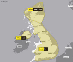
The yellow warning warns of a 'medium' level likely impact to residents and services across the region, with the group saying that clear skies and colder temperatures overnight could lead to icy patches on Wednesday morning.
The new weather warning is expected to stay in place until 10am on Wednesday, however, the Met Office has warned UK will continueto experience a range of 'winter weather hazards' through the week.
A Met Office spokesperson said: "Following a band of precipitation which clears southeast overnight, clear skies will develop for many areas on Tuesday night, leading to icy patches on untreated wet surfaces.
"This could lead to some minor disruption, especially on Wednesday morning."

It comes as schools continue to remain closed across the West Midlands and Shropshire today, with many choosing to stay shut due to 'unsafe driving conditions' for teachers and parents.
Commenting on the weather forecast for the West Midlands, A Met Office spokesperson said: "The UK will continue to experience a range of winter weather hazards through this week, with low temperatures as well as snow showers and the risk of ice for many.
"A number of severe weather warnings have been issued, and these are likely to be updated through the week, so do keep up to date with the forecast."
Latest Met Office weather forecast for the West Midlands.
Today:
A mostly dry day, though often rather cloudy. Some brighter breaks are possible, mainly in the south. A few light wintry showers are possible. Tending to cloud over by late afternoon. Breezy and feeling cold once more. Maximum temperature 4 °C.
Tonight:
A band of rain sleet and hill snow will move eastwards across the region through the evening, clearing during the early hours. Icy stretches developing where skies clear later. Minimum temperature -2 °C.
Wednesday:
Another cold day is expected, with rather cloudy skies. A scattering of sleet and snow showers, these tending to ease later in the day. Gusty winds. Maximum temperature 5 °C.
Outlook for Thursday to Saturday:
Most likely dry initially on Thursday. Then an increasing risk of heavy rain, sleet and snow, along with strong winds, which may linger into Friday. Sunshine and wintry showers Saturday.