Date autumn starts as Hurricane Erin forecast to bring band of rain to UK
Watch the latest Met Office video forecast, as an increased likelihood of low pressure, spells of rain and increased winds is forecast.
With unsettled weather potentially on the way for next week, we’ve taken a look at when autumn starts and whether it could make an early appearance this year.
When does autumn start?
Astronomical autumn
According to the Met Office, when people talk about the first day of autumn they’re referring to the astronomical autumn - defined by the Earth's axis and orbit around the Sun.
This year astronomical autumn begins on September 22 and ends on December 21.
Meteorological autumn
The meteorological seasons are four periods of the year made up of three months each. The seasons are split to coincide with our Gregorian calendar, making it easier for meteorological observing and forecasting to compare seasonal and monthly statistics.
In the meteorological calendar, autumn will always start on September 1 and end on November 30.
Could autumn start early?
Signs of autumn, like leaves falling and apples being ready to pick., can be seen in the UK. Experts say this is due to nature becoming stressed by the long hot and dry summer.
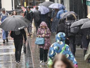
Aidan McGivern, Met Office meteorologist, said: “What looks most likely is that that ex-hurricane [ex-Hurricane Erin] fuels the jet stream, the jet stream brings a big change to the UK’s weather into next week, brings an increased likelihood of low pressure, showers, spells of rain and increased winds as well.
“Of course, we need the rain, but it might not be welcome for people who want to enjoy the last week of the summer holidays. It does look a little bit more likely that autumn could make an early appearance.”
What could the weather be like next week?
Tony Wisson, Met Office Deputy Chief Meteorologist, said: “There’s still a lot to work out in terms of the exact track and position of what will become Ex-Hurricane Erin. This system should have undergone its transition into an ex-hurricane by the time it reaches the mid-Atlantic, and it will continue to weaken as a broad low pressure system as it then drifts towards the UK. This will displace our current settled weather, bringing spells of rain and perhaps strong winds in places by the middle of next week.
“Tuesday is when we’re likely to see the start of this influence, with a band of rain pushing from west to east over the UK. Rainfall could be heavy for a time in parts of the west, though it’s too early to be precise with details on this.”