Shorts to shivers in one day
What a difference a day makes. The West Midlands moved from shorts to snow inside 24 hours.
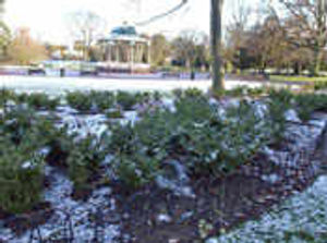
Spring-like temperatures of 16C (61F) at the weekend turned into very cold ones this morning.
Snow that fell across the region overnight had mostly melted away by rush hour but weather experts said that the cold snap was here to stay for most of the week – and that means more of the white stuff to come.
Express & Star weatherman John Warner said that the region could expect scattered snow showers today and tomorrow.
He said temperatures would drop to -2C (28F) tonight and as low as -4C (25F) on Tuesday night.
Mr Warner said that was an amazing turnaround from Saturday when the West Midlands was the warmest place in the country.
He said radical shifts in weather were not unusual in early spring.
"It's quite a dramatic drop in temperature," said Mr Warner.
"Instead of having perpetual mildness you get alternate cold and mild spells which is quite common in early spring." Gritters went out across the region overnight and remained on standby this morning.
Tim Clark, spokesman for Wolverhampton City Council, said: "Our gritters went out last night. The temperatures stayed just above freezing so it was more of a precaution. They put salt down on the road network in case it was required."
Gusting winds toppled a cherry tree on a main traffic island leading into Kidderminster from the A449 Worcester Road this morning. Police warned drivers in the area to take the road conditions into account on their journeys.
After Wednesday, temperatures will rise slightly back to average levels for this time of year, but Mr Warner warned that warm weather was some time off.
The West Midlands was hit by severe snow falls early in February, causing widespread travel disruption. Drivers were caught on gridlocked roads throughout the region as journeys home of just a few miles turned into five or six hour trips.