
Residents fear 'mega sheds' near M5 will loom over homes
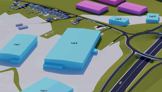

The site will eventually form part of the new Wychavon Town
Residents fear plans for a business park near Worcester will lead to huge “mega sheds” looming over their homes.
The proposed industrial units, which could be up to 22 metres tall, have been likened to large warehouses at the centre of a planning row in Wigan that has made national headlines.
Hallam Land has put forward plans for more than 30 hectares of employment land near junction 7 of the M5, accessed from the Pershore Road.
The developer says the site will eventually form part of the new Wychavon Town, which is being planned around Worcestershire Parkway railway station.
It says this plot “will deliver up to 720,000 square feet of employment buildings” and includes plans for a petrol station.
But residents are concerned about the size of some of the buildings proposed.
One said: “For perspective, these buildings will stand higher than the nearby Whittington Tump, which rises 20 meters above the valley floor.
“There are also separate, independent proposals for additional warehousing to the south of Pershore Road, which would further overwhelm the landscape.
“The scale of these mega sheds and their impact on the local environment is substantial.”
He said the scheme “highlights a growing trend of industrial over-development encroaching on rural landscapes”.
Barry Collins said: “The scale of the proposal – including large warehouses, service yards, HGV routes, parking and associated commercial uses – would fundamentally change the character of Whittington.”
Reuben Ball said: “Industrial and warehouse buildings of this size would be visually dominant and out-of-keeping with the rural village setting and surrounding countryside.”
Hallam Land said industrial buildings north of Pershore Road would be up to 22 metres tall and those south of Pershore Road would be a maximum of 12 metres high, to respect existing views towards Crookbarrow Hill, also known as Whittington Tump.
“The height of buildings will be considered carefully to maximise usability of the development while also considering visual impact on the surroundings,” the developer said.
“The M5 motorway embankment to the west and low lying topography of the site in combination with carefully considered building heights will allow for the development to have a reduced visual impact.”
Comment Guidelines
Iconic Media encourages reader discussion on our stories. User feedback, insights and back-and-forth exchanges add a rich layer of context to reporting. Please review our Community Guidelines before commenting.