Garden dug up as new photos show scale of Wolverhampton sinkhole
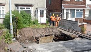
A front garden has been dug up as work continues to repair a sinkhole in the Black Country.
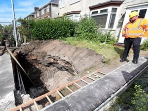
New photos reveal the scale of the cavity which appeared in Millfields Road, Ettingshall, Wolverhampton, on Monday evening .
The road was closed off and residents from three nearby houses evacuated, with the hole found to be around three metres deep and three metres wide.
The evacuated residents all live between the canal bridge and Chem Road, with one family being rehomed temporarily in a hotel.
Workers were at the scene throughout Tuesday and Wednesday and now more of the nearby surface has been removed, the scale of the hole is visible.
The Coal Authority has since been carrying out emergency work to fill in the hole, which is deep enough for workers to need a ladder to climb down.
The Government-backed authority said the sinkhole is a crown hole, meaning it is associated with a shallow coal mine workings collapse and not a vertical mine shaft.
A spokesman for Wolverhampton Council said workers from the authority "acted fast" to close the road for both safety reasons and enable emergency works.
They said on Monday that The Coal Authority would continue to "infill the collapse and repair the damaged sewers over the coming days."
Meanwhile the eastbound carriageway on the road is likely to be closed until the works are completed, with a diversion put in place via Ettingshall Road, Bilston Road, Wellington Road and Wolverhampton Street.
Wolverhampton Council has been approached for an update.