More than 400 schools shut as Scotland set for ‘highest level snow warning’
A red weather alert means a high potential of ‘widespread damage’, travel and power disruption and risk to life.
More than 400 schools across Scotland have been forced to shut as the country gets braced for snow with potentially the highest level of warning from forecasters.
Transport Minister Humza Yousaf said amber alerts for snow and freezing winds from the early hours of Wednesday could be changed to red for extreme weather in certain areas, with motorists urged not to travel.
East Dunbartonshire Council, City of Edinburgh Council, Falkirk Council, Fife Council, Scottish Borders Council, Stirling Council and East Renfrewshire Council announced all schools in their areas will be closed on Wednesday due to potential of dangerous conditions.
Mr Yousaf told BBC Radio Scotland: “There is a possibility that the amber warning could be in some areas upgraded to a red.
“That is a warning for snow that we have never seen since the modern system has come into place in Scotland, that’s what the Met Office tell me.
“We are right on the cusp, we are at the strongest possible amber warning, and right on the cusp of potentially becoming a red.
“That means a high likelihood of a high impact so that could be not just treacherous but frankly dangerous if you travel.”
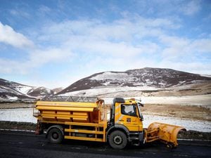
Forecasters said the entire east coast, central belt and as far west as Greenock will be hit – while the worst affected areas could see up to 40cm of snow and a wind chill of minus 10C.
Police Scotland has urged motorists in affected areas not to travel by road, however other transport services are likely to be impacted.
A red weather warning means a high potential of “widespread damage”, travel and power disruption and risk to life.
Met Office advice for such alerts is to “avoid dangerous areas and follow the advice of the emergency services and local authorities”.
As the so-called “Beast from the East” hit Scotland on Tuesday, travel routes saw disruption caused by difficult driving conditions while some areas had power cuts.
Giving a forecast for Wednesday and Thursday north of the border, Met Office meteorologist Aidan McGivern said: “With the snow coming increasingly aligned into bands accompanied by strong winds there is the risk of blizzards and the risk of really significant snow accumulations building up – 5cm to 10cm widely (in the amber area) with 15cm to 25cm locally and the potential for the hills to see 40cm of snowfall building up by the end of Thursday.
“Maximum temperatures on Wednesday will be barely above freezing and adding in that keen easterly wind it will feel more like minus 10C.”