Thunder expected across the region for coronation weekend
The coronation weekend might have a backdrop of thunder and overcast skies, the Met Office warns.
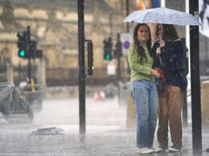
With the King's coronation just around the corner, people are getting ready to host street parties and celebrations – but they may need to be kept indoors.
Wolverhampton, the Black Country and Staffordshire last week were expected to have a "dry and mild" coronation weekend, but the Met Office has now predicted showers and thunder in some areas.
Outlook for Friday to Sunday in the West Midlands:
The Met Office overview for the coronation weekend sees sunny spells and showers, with Friday being heavy and thundery in some areas. Saturday with sunny spells, but showers and rain later in the day. Sunday sees a cloudy start then further heavy showers, with winds easing.
Friday, May 5: Friday is expected to be cloudy, changing to light showers by late morning. It will still be relatively warm, reaching highs of 16 degrees and lows of ten. There is a 60 per cent chance of rain early morning, changing to 40 percent from 10am to 1pm.
Saturday, May 6: The day of the coronation will also be cloudy with an overcast in some areas, changing to light rain by lunchtime. Saturday will be mild with highs of 15 degrees and lows of 11. There is a 10% chance of rain in the morning changing to 40 per cent by 1pm, but there will still be sunny spells. Dark clouds and rain is predicted between 4pm - 7pm.
Sunday, May 7: Sunday morning is expected to be overcast with dark clouds, changing to light showers by lunchtime. There is a 30 per cent chance of rain in the afternoon, highs of 17 degrees and lows of ten.
Monday, May 8: Bank holiday Monday will again be cloudy with overcast in some areas, changing to light showers in the afternoon. There is a 40 per cent chance of rain later in the afternoon too, but temperatures will remain mild at highs of 16 degrees and lows of 11.