
New weather warning until Saturday as sub-zero temperatures grip the West Midlands
Two weather warnings for ice have been issued across the West Midlands as freezing temperatures grip the region.
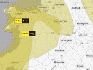
A new Met Office yellow warning runs until midday on Saturday, while the other expires at midday today, as temperatures struggle to get above 0C over the coming days.
The warnings cover much of the West Midlands, including parts of the Black Country and Staffordshire, as well as neighbouring Shropshire and Worcestershire. Other parts affected include Cheshire, Herefordshire and almost all of Wales.
Forecasters are warning people to expect icy patches on some untreated roads, pavements and cycle paths as a result of "frequent wintry showers" which are likely to fall on frozen surfaces.
The Met Office warns of showers spreading from the west, with the chance of snow on high ground, particularly in North Wales.
Thursday's forecast for the West Midlands read: "Frost, patchy low cloud and any fog clearing to leave a dry day with increasing amounts of sunshine. Light winds, but remaining cold with temperatures staying in low single figures. Maximum temperature 3°C."
Looking ahead to tonight, the Met Office added: "Cloud will gradually increase from the north this evening bringing a few wintry showers. However, skies will clear again during the early hours. Another widespread sharp frost forming. Light winds. Minimum temperature -7°C," while Friday's forecast said: "A cold and frosty, but sunny start, and plenty of sunshine through the day. Increasing cloud perhaps giving the odd wintry shower in the northwest later. Light winds. Maximum temperature 2°C."
Temperatures across the Black Country and Staffordshire are set to dip below freezing each day over the next six days, with lows of -4°C expected, although people are being warned it could feel as cold as -6°C at times.