Where and when thunderstorms are expected to hit the region
Thunderstorms and heavy rainfall are set to hit the region today after a week of scorching heat.
The Met Office issued a yellow warning for the West Midlands for thunderstorms which are expected to run through until Tuesday night (August 16).
According to weather reports, the Black Country and South Staffordshire will see multiple thunderstorms both today and tomorrow.
The Met Office said in its weather warning: "Hit-and-miss thunderstorms likely to develop through Monday, producing some torrential downpours for some spots, and possible disruption.
"Spray and sudden flooding could lead to difficult driving conditions and some road closures.
"There is a small chance that homes and businesses could be flooded quickly, with damage to some buildings from floodwater, lightning strikes, hail or strong winds.
"Where flooding or lightning strikes occur, there is a chance of delays and some cancellations to train and bus services.
"There is a slight chance that power cuts could occur and other services to some homes and businesses could be lost."
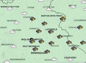
According to the Met Office weather map, thunderstorms will hit the region around 1pm today.
The rest of the day in the West Midlands is set to be cloudy only with no thunderstorms expected.
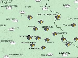
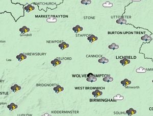
However, on Tuesday, August 16, there are thunderstorms expected across the region for most the day.
The Met Office weather map shows thunderstorms are expected across the region from around 10am.
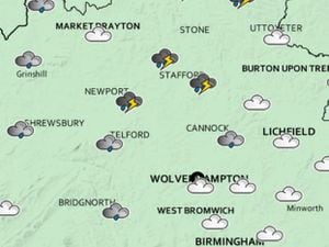
And the stormy weather is expected to continue well into the afternoon with many thunderstorms around 4pm.