Clear-up after Storm Francis wreaks more havoc across region
The effects of Storm Francis have continued to be felt today after homes and businesses took another battering this week.

A mixture of winds of up to 70mph and heavy rainfall caused havoc across the Black Country and Staffordshire on Tuesday and into Wednesday, leaving debris and damage on roads and around homes.
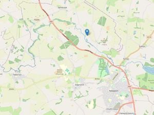
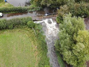
On Tuesday rescue teams were called out to Trescott Ford, a notorious flooding spot between Bridgnorth and Wolverhampton, after reports of a vehicle being submerged in fast flowing water from Smestow Brook.
Sam Burke, incident manager for Burke Bros Recovery, attended the scene and talked about what the service did to remove the car.
He said: "Multiple operational vehicles were sent to the scene with our water rescue technicians, a incident manager, our technical rescue team and a lorry loader crane.
"The vehicle was then lifted from the water onto our recovery unit in a fast response and safe recovery process, which is vital to remove vehicles from water which can lead to environmental pollution."
Smestow Brook was one of a number of rivers to flood or have flood warnings given due to the storm, with roads and farmland affected by rising levels on the River Sow and River Penk.
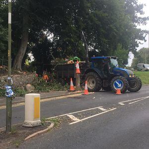
A tree collapse caused delays in Halesowen today after blowing down on Furnace Lane, with a crew working to remove the debris from the scene, while, in Kingswinford yesterday, strong winds caused bins to fall into parked cars, cladding was ripped off houses and drivers were delayed after a large tree branch broke off a tree on Bromley Lane, following strong gusts of wind.
Anthony Plant was at the scene awaiting road side assistance for a broken down car around 5pm and described the scene.
He said: "I was waiting for roadside recovery and could see the trees bending in the winds and now and again, there would be a few minutes of very strong gusts.
"I saw a few wheelie bins hit parked cars on people's driveways and mentioned to my friend that I could see one of the trees falling and, 30 minutes later, we heard a loud snap and crash.
"While taking the photos, I heard another crash and directly behind me, the whole cladding had been blown off someone's garage front and scattered all over the driveway."
Bank holiday chill
The forecast for the rest of the week points to winds easing and much of the remaining rain in the north clearing away quickly, with some isolated showers for the remainder of the day, while the UK is set for a bank holiday chill to follow Storm Francis.
Across the rest of the UK the clear-up has begun after the storm, which saw gusts of 81mph hit The Needles near the Isle of Wight on Tuesday.
This is just short of the August record for the UK which was 87mph recorded in 1996.
North Wales Police said that flooding and a landslide had closed the A5 on Wednesday morning from Bethesda to Betws y Coed.
Carl Foulkes, the Chief Constable at North Wales Police, tweeted: “A really busy night across the force with colleagues working with fire and local authorities to manage impact of storm Francis.
“Still a number of roads closed and we continue to monitor impact of rain.
“Important that everyone stays alert and safe.”
The Environment Agency had 19 flood alerts in place across England at Wednesday lunchtime.
Storm Francis, which hit just days after Storm Ellen struck, has cleared to the east of Britain but there still is “some disruptive weather” to get through on Wednesday to Friday before things become “settled but more chilly for the bank holiday weekend,” according to Met Office forecaster Bonnie Diamond.
Storm Ellen’s gales brought the highest ever share of wind power on the electricity system as wind turbines supplied 59.1% of Britain’s power on Saturday at 1am, according to National Grid ESO.
A spokesman said “it means that wind was contributing more than it has ever done to the electricity system at just shy of 60%”.
The impact of Storm Francis saw gusts of 75mph at Lake Vyrnwy in Powys, Wales, on Tuesday, equalling the Welsh August gust record at Milford Haven in August 1979.
The wettest place on Tuesday was Bethesda in north Wales where 101mm of rain was recorded.
Meanwhile, the fire service in Northern Ireland said 37 people were rescued from flood water.
Elderly residents had to be rescued from the County Down coastal resort town of Newcastle after a river burst its banks, and in Draperstown, Co Londonderry, rescuers had to save nine people from inside a house, along with four outside who were trying to help.
A boat was used to help residents in Newcastle, a picturesque east coast town on the edge of the Mourne Mountains.
Up to 300 homes have been affected and streets left under three or four feet of water, a local representative said.
South Wales Police said they were involved in two separate water searches from the swollen River Taff and fire crews had to rescue holidaymakers from a flooded campsite in the town of St Clears, Carmarthenshire, after river levels rose in the area.
Mid and West Wales Fire and Rescue Service said nine people and two dogs were rescued by fire service personnel using a swift rescue sledge, lines and wading gear.
Crews also gave medical treatment to one man and evacuated 30 other people from a flooded caravan site in Wiseman’s Bridge, Narberth, while 12 caravans were also removed from the site.
Ms Diamond said: “The latter part of August has been dominated by Storm Ellen and Storm Francis, both of which had wind warnings which is unusual for August, but then if you rewind to the beginning of the month, we had no wind at all.
“We had high temperatures, light winds and exceptional heat which lasted for about a week. It has been an interesting month, starting out with a hot summer and seeing its way out with more autumnal weather.”
Scotland is set for showers and lighter winds on Wednesday and will brighten up in the afternoon. Top temperatures in the sunshine could hit about 22C in southern England.
Showers are also expected for Northern Ireland, southern Scotland, northern England and south-west England plus parts of Wales on Thursday afternoon.
Dry weather is expected for central and eastern England and the far north of Scotland.
Ms Diamond said that daytime temperatures in the south of England could then reach highs of 18C or 14C in Scotland “which is cool for August but it will be pretty chilly overnight”.
By Friday night onwards, many places will struggle to get temperatures that are in the double digits, she added.