Snow and icy conditions expected in the wake of Storm Caroline
Snow and icy conditions are set to arrive in the West Midlands later this week, as the Met Office issues a yellow weather warning.
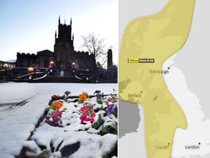
Following warnings earlier in the week, the Met Office has released a map of the areas most likely to be affected by the upcoming cold snap between the early hours of Friday and around 6pm on Saturday. They have predicted 2-5cm of snow for parts of England, with 10-20cm possible over high ground, mostly in Scotland, Wales and Northern Ireland.
The icy spell is due to arrive on the back of Storm Caroline, which although mainly affecting Scotland should bring strong winds and wet, blustery weather to the rest of the UK towards the end of the day and the start of Thursday.
Met Office meteorologist Marco Petagna said: "Wednesday will see the last of the mild days, with temperatures in double figures, between 10 and 12 degrees (50F-54F).
"Overnight, the main feature will be the increase in wind as Caroline starts to come in towards the end of the night."
Met Office weather forecast warns of stormy weather in the North followed by a cold snap for the UK
Coastal communities are likely to be affected by spray or large waves.
Friday will see a 9° drop in temperature from the day before, with highs of 1C (33.8F) and lows of freezing in Wolverhampton. Snow is forecast throughout the day. Saturday is looking cold and sunny, with temperatures due to drop as low as -1C (30.2F). The Met Office warns drivers, cyclists and pedestrians to take extra care on potentially icy roads and paths.