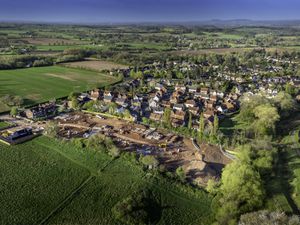
West Midlands Roman roads revealed in London tube-style map
They built 2,000 miles of famously straight roads across the UK - including highways through Staffordshire and the West Midlands that are still used today.
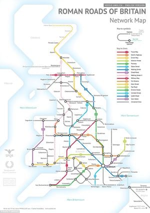
Now a London Underground-style map of Roman roads has been drawn up by a student studying statistics at the University of Chicago. The colourful network simplifies the road system of 43 – 410 AD Britain for modern readers.
The map looks very different to a 21st century A-Z or road atlas, with no sign of how important Birmingham or the Black Country conurbation of Wolverhampton, Dudley, Sandwell, and Walsall would become - and no trace of an M6, M54, A449, A454 or an A41.
The only local towns shown on student Sasha Trubetskoy's subway map are Penkridge, given its Latin name of Pennocrucium, and Wall, then called Letocetum, both important stopping-off places on the Romans' long journeys around the country.
One of their most important routes was Watling Street, the Roman military road to North Wales, which ran from east to west, beneath the modern A5 trunk road.
Pennocrucium was around three miles south-west of the modern town of Penkridge. Wall was near the junction of Watling Street and Icknield Street, also shown on the map, now known as the A38. Both were important military staging posts for the Romans, providing accommodation, baths and a change of horses.
The Via Devana was another road built for military use rather than to serve the local population, which was very sparse in these parts during Roman times. It ran from Colchester in the south-east through Wall and Penkridge to Chester, which lays claim to being the oldest Roman city in Britain. The road later fell into disuse.
All the roads were designed to allow troops to move quickly, and also provided vital routes for business, trade and the transportation of goods.
While the roads were very advanced for their time, transport itself was not so sophisticated, and a journey from London to York, which today would take four hours by car, would have taken five days to complete in a carriage.
Roman roads were typically 16 to 23ft (five to seven metres) wide. Their preservation in the UK varies, with some still protruding from the land and easily visible while others are hidden under earth and have only been found thanks to light detection scanning.
Within the map, the dots and circles show the cities, towns and settlements, while the different coloured lines denote the roads, with a key explaining these on the right. It includes the Latin names for towns and cities across the UK, such as Londinium (London), Mamucium (Manchester) and Pons Aelius (Newcastle-Upon-Tyne).
Mr Trubetosky, who spent days making the map, said: "I pretty much included every known Roman settlement in Britain, as well as some locations that were only a fort/camp, or tribal settlement under Roman control.
"I did have to exclude a few cities, though, mostly because they were very small and would not fit on the map without significant distortion."
While Latin names are given for the towns and cities, the lines themselves all have modern English names, such as Devil's Highway and Military Way, because the original Latin names have been lost to history.
While transport around the UK is now fairly fast, Mr Trubetosky explained that travelling around the country during the Roman era would have been much slower.
He said: "Speed of travel depends on the season, mode of travel, and how rich you are. An expensive fast carriage could take you from London to York in about five days.
"Most people couldn't afford animals or carriages, and would have to go on foot - at that rate London to York would take nearly two weeks."
This is not the first time that Mr Trubetosky has re-imagined Roman roads as a modern subway system. In June, he created a similar map showing the Roman roads around Europe.