Lightning and flash floods as heavy rain hits West Midlands
Heavy rain battered the West Midlands today, sparking flash flooding and forcing outdoor events to be cancelled.
After sweltering in temperatures that touched on 32C (89.6F), the UK is now facing for torrential downpours and storms.
The Environment Agency warned that up to 30mm (1.2in) of rain could fall in an hour in some areas.
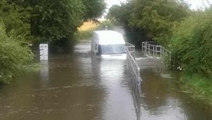
There was flooding on the Tettenhall Road and Birmingham New Road in Wolverhampton, and in Albrighton. Burntwood Wakes Festival was cancelled today and tomorrow.
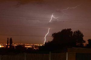
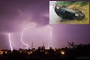
Express & Star reader Demi-leigh Freeman captured this image of lightning in Dudley.
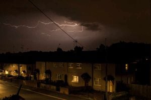
While Twitter user @thewulfran snapped this scene over Aldridge
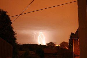
Twitter user @B1Bobs even managed to capture an apparent strike on Birmingham's landmark BT tower.
Click here to see the latest across the country
Travel reporter Tom Stokes (@thetomstokes) tweeted this video of flooding on Birmingham New Road:
The agency says that almost every county in England and Wales is at "medium" risk of flooding today, and has issued 59 flood alerts, warning people to be prepared.
The majority of these are in the Midlands, the South East and the South West.
Follow live updates as flash floods hit the region
In a separate "amber" warning of rain for England, eastern and central Wales, the Met Office warns that heavy, thundery showers that developed overnight will move northwards during the day.
Large amounts of energy in the atmosphere will lead to torrential downpours, frequent lightning, large hail and strong gusts of wind.
At least one vehicle got stuck in Trescott Ford, which is notoriously difficult to negotiate during heavy rain.
The Met Office said: "Not everywhere within the warning area will see thunderstorms, and indeed some spells of warm sunshine are expected at times, but where thunderstorms do form, some torrential downpours are likely with frequent lightning, large hail and locally strong gusts.
"Significant flooding is possible where these do occur from surface water as well as from small, fast-responding watercourses. The public should be prepared for the risk of disruption from any of these elements."
There is still, however, a "yellow" warning of a heatwave for the UK today, advising people to be "alert and ready". The Met Office said there was a 60% chance of a heatwave continuing until tomorrow morning, with high levels of humidity.
John Curtin, director of incident management at the Environment Agency, said: "Intense heavy rainfall this weekend brings a surface water flood risk for England throughout the weekend. Flooding can happen very quickly and the public are urged to keep checking local weather forecasts and the Environment Agency website for information on a regular basis.
"We will continue to monitor the situation closely and support local authorities, who will respond to any reports of surface water flooding. We will also continue to monitor river levels closely and issue warnings where flooding is likely."
Storms hit large parts of the South East of England early yesterday morning, with a reported 3,000 lightning strikes.
Gemma Plumb, a forecaster with MeteoGroup, said: "Today we have got some heavy and severe thunderstorms continuing to spread north across the UK. Most of the UK is going to see some heavy showers or long spells of rain during the day and severe thunderstorms.
"These could give hail, gusty winds and very frequent lightning strikes.
"It will not be as hot as yesterday, but it will still be very warm and humid. East Anglia could still see temperatures as high as 27C (80.6F) to 29C (84.2F), Kent will see 27C (80.6F) or 28C (82.4F), rather than the 32C (89.6F) it had yesterday."
Fire crews have been called to a number of incidents caused by lightning.
The first floor and roof of a house in Sittingbourne, Kent, was set alight by a strike, while a bungalow's roof was hit in Whitstable, Kent Fire and Rescue said.
Houses were struck in the market village of Lenham, near Maidstone, while lightning also started several small fires in Willesborough, near Ashford.
A spokeswoman for Heathrow Airport said airlines were cancelling 20% of flights for a two-hour period today due to the thundery weather.
She said: "There is severe weather forecast at Heathrow with a 70% risk of thunderstorms, lightning strikes and hail storms. During thunderstorms the number of aircraft that can take off and land each hour is reduced.
"We have therefore requested that airlines reduce their flight schedule by 20% between 4pm and 6pm. Passengers due to travel on July 19 are urged to check the status of their flight with their airline before travelling to the airport."
Manchester Airport said an electrical surge caused by thunderstorms had led to some delays today.
General duty manager Gary Brown said: "It impacted on some lifts and baggage systems but most systems are now back up and running.
"We'll wait to see what happens this afternoon when we're expecting thunder."