Midlands to be hit by first snow of winter
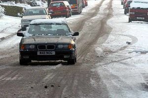
Heavy snow is on the way to the Midlands tonight as the first big freeze of winter arrives. Forecasters say an icy blast will turn rain to snow.
Heavy snow is on the way to the Midlands tonight as the first big freeze of winter arrives. Forecasters say an icy blast will turn rain to snow.
This will higher ground especially, with temperatures plummeting over the next few days.
Up to four inches of snowfall is expected from 3am tomorrow, prompting warnings to motorists of problems during rush hour.
Temperatures will hit 5C (41F) today with sunny spells before plunging to 0C (32F) overnight as the snow begins to fall.
The Met Office has issued warnings of severe icy conditions until the weekend.
Colder than average temperatures will continue until Sunday evening and are only expected to improve by Monday.
Met Office forecaster Anthony Astbury said: "The unsettled weather over the next few days could bring a range of hazards across the country, from snow and ice to heavy rain and strong winds.
"We're working closely with Government agencies and the resilience community to keep them up-to-date with the latest information."
Gritting lorries have been out in force across the region overnight in an attempt to keep the highways clear of frost.
The country has been battered by weather for a week but the West Midlands has so far escaped the worst.